Have your say
Te Kupenga o Ngati Kuta and Patukeha ki Te Rawhiti have made a request to the Ministry for Primary Industries (MPI) for a further temporary closure at Maunganui Bay regarding the take of all fisheries resources, except kina.
Written submissions in response to this request are invited from persons who have an interest in the species concerned or in the effects of fishing in the area concerned.
A public notice calling for written submissions is in The Northern Advocate on Saturday 2 July 2016.
Background to consultation
Pursuant to section 186A of the Fisheries Act 1996 (the Act), MPI has received a request from Te Kupenga o Ngati Kuta and Patukeha ki Te Rawhiti for a further 2-year temporary closure of Maunganui Bay to the take of all fisheries resources, except kina. The current temporary closure is due to expire on 29 October 2016.
Section 186A provides that the Minister for Primary Industries may temporarily close an area, or temporarily restrict or prohibit the use of any fishing method in respect of an area, if satisfied that the closure, restriction, or prohibition will recognise and provide for the use and management practices of tangata whenua in the exercise of non-commercial fishing rights by:
- improving the availability and/or size of fish, aquatic life, or seaweed
- recognising a customary fishing practice.
Te Kupenga o Ngati Kuta and Patukeha ki Te Rawhiti consider that a further 2-year closure will provide continued statutory support for a customary rahui placed over the Bay in 2009, and allow continued enhancement of the local fisheries.
Details of proposed temporary closure
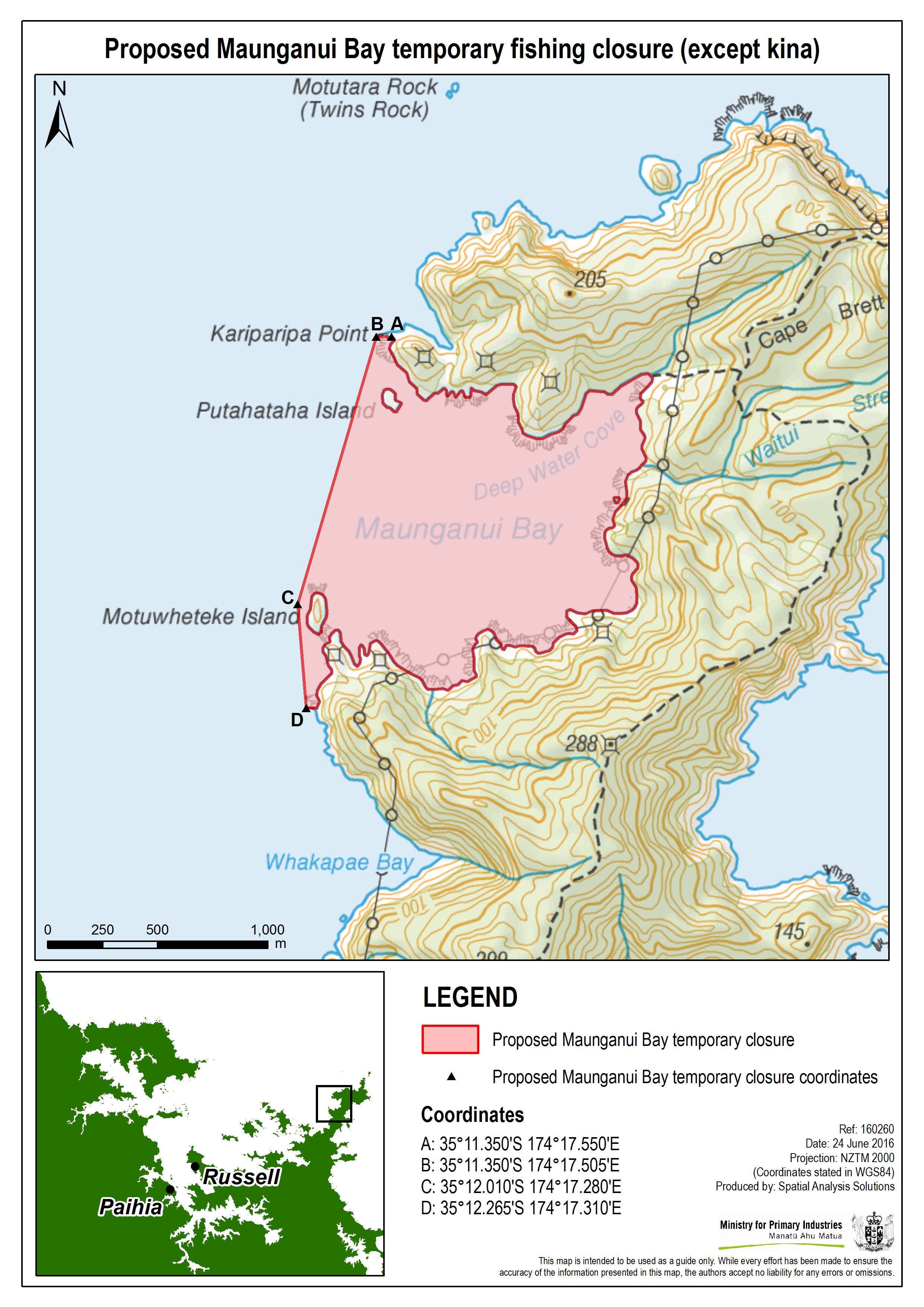
The proposed temporary closure covers all that area of New Zealand fisheries waters enclosed by a line commencing at Kariparipa Point (35°11.350'S and 174°17.550'E); then proceeding in a straight line due west to a point at 35°11.350'S and 174°17.505'E; then proceeding in a straight line in a south westerly direction to a point off the western side of Motuwheteke Island (35°12.010'S and 174°17.280'E); then proceeding in a straight line in a south south-westerly direction to a point at 35°12.265'S and 174°17.310'E; then proceeding along the mean high-water mark to the point of commencement. The proposed temporary closure covers approximately 1.6 sq km.
A detailed map of the proposed area is available, or email MPI for a copy – FMSubmissions@mpi.govt.nz.
Maunganui Bay temporary closure map
Making a submission
Email your feedback on the consultation document by 5pm Tuesday 2 August to FMSubmissions@mpi.govt.nz.
Make sure you include in your submission:
- the title of the consultation document in the subject line of your email
- your name and title (if applicable)
- your organisation's name (if applicable)
- your address.
While we prefer email, you can send your submission by post to:
Fisheries Management – Customary Fisheries and Spatial Allocations
Ministry for Primary Industries
Private Bag 14
Nelson 7042
New Zealand.
Submissions are public information
Note that your submission is public information. Submissions may be the subject of requests for information under the Official Information Act 1982 (OIA). The OIA specifies that information is to be made available to requesters unless there are sufficient grounds for withholding it, as set out in the OIA.
Submitters may wish to indicate grounds for withholding specific information contained in their submission, such as information being commercially sensitive or they wish personal information to be withheld. MPI will take such indications into account when determining whether or not to release the information. Any decision to withhold information requested under the OIA is reviewable by the Ombudsman.