Customary fisheries management areas
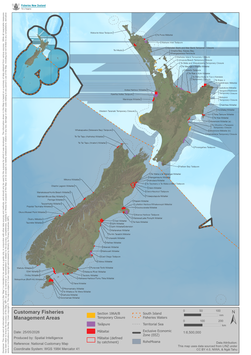
Types of customary management areas
Customary management areas include:
- mātaitai reserves – areas closed to commercial fishing, that may have bylaws affecting recreational and customary fishing
- taiāpure – local fisheries of special significance, that may have additional fishing rules
- temporary closures – issued under sections 186A or 186B of the Fisheries Act 1996
- customary bylaw areas – currently only in the Waikato-Tainui area.
Check the rules before you fish
Before you go fishing, make sure you're aware of the different customary management areas, any local rules, and your obligations as a fisher.
Customary management areas
Mātaitai |
Location |
Date established |
Area (km2) |
Bylaws |
---|---|---|---|---|
Te Puna [PDF, 978 KB] |
Bay of Islands |
29 August 2013 |
20 |
|
Mt Maunganui and part of Tauranga Harbour [PDF, 3.1 MB] |
Bay of Plenty |
25 September 2008 |
7 |
|
Te Rae o Kohi [PDF, 15 MB] |
Bay of Plenty |
17 May 2018 |
6.9 |
|
Raukokere [PDF, 3.8 MB] |
Bay of Plenty |
12 August 2005 |
26 |
|
Te Kopa o Rongokānapa [PDF, 311 KB] |
Bay of Plenty |
29 June 2020 |
70 |
|
|
Waikato |
8 May 2008 |
40 |
|
|
Waikato |
13 January 2011 |
68 |
|
|
Gisborne |
4 August 2011 |
4 |
|
Horokaka [PDF, 288 KB] |
Mahia Peninsula |
13 September 2012 |
4 |
Horokaka bylaw notice |
Toka Tāmure [PDF, 288 KB] |
Mahia Peninsula |
13 September 2012 |
3 |
|
Te Hoe [PDF, 288 KB] |
Mahia Peninsula |
13 September 2012 |
15 |
|
Moremore [PDF, 3.8 MB] |
Napier, Hawkes Bay |
12 August 2005 |
16 |
|
Mātaitai |
Location |
Start date |
Area (km2) |
Bylaws |
Anatori [PDF, 233 KB] |
Tasman |
13 January 2011 |
15 |
|
Kaihoka [PDF, 216 KB] |
Tasman |
13 January 2011 |
5 |
|
Okarito Lagoon [PDF, 237 KB] |
West Coast |
13 September 2012 |
19 * |
|
Manakaiaua/Hunts Beach [PDF, 601 KB] |
West Coast |
22 September 2011 |
less than 1 |
|
Mahitahi/Bruce Bay [PDF, 631 KB] |
West Coast |
22 September 2011 |
1 |
|
Tauparikaka [PDF, 2 MB] |
West Coast |
22 September 2011 |
less than 1 |
|
Okuru/Mussel Point [PDF, 584 KB] |
West Coast |
22 September 2011 |
less than 1 |
|
Te Waha o te Marangai [PDF, 1.7 MB] |
Kaikōura |
8 August 2014 |
2 |
|
Mangamaunu [PDF, 1.7 MB] |
Kaikōura |
8 August 2014 |
2 |
|
Kahutara [PDF, 13 MB] |
Kaikōura |
10 October 2018 |
n/a * |
|
Oaro [PDF, 12 MB] |
Kaikōura |
10 October 2018 |
less than 1 * |
|
Tūtaeputaputa [PDF, 16 MB] |
Kaikōura |
10 October 2018 |
n/a * |
|
Lyttelton Harbour/Whakaraupo [JPG, 4.5 MB] |
Banks Peninsula |
20 July 2017 |
30 |
|
Rapaki Bay [PDF, 581 KB] |
Banks Peninsula |
18 December 1998 |
less than 1 |
|
Banks Peninsula |
15 December 2000 |
8 |
||
Wairewa/Lake Forsyth [PDF, 242 KB] |
Banks Peninsula |
8 July 2010 |
6 * |
|
Te Kaio [PDF, 149 KB] |
Banks Peninsula |
16 December 2010 |
12 |
|
Opihi [JPG, 1.7 MB] |
South Canterbury |
7 August 2014 |
n/a * |
|
Waitarakao [JPG, 1.7 MB] |
South Canterbury |
7 August 2014 |
less than 1 * |
|
Te Ahi Tarakihi [PDF, 760 KB] |
South Canterbury |
21 July 2016 |
1.5 |
|
Tuhawaiki [PDF, 760 KB] |
South Canterbury |
21 July 2016 |
4.1 |
|
Waihao [PDF, 325 KB] |
South Canterbury |
13 September 2012 |
4 * |
|
Moeraki [PDF, 170 KB] |
North Otago |
16 December 2010 |
3 |
Moeraki bylaw area map [PDF, 203 KB] |
Waikouaiti [PDF, 1.2 MB] |
Otago |
21 July 2016 |
n/a * |
|
Otakou [JPG, 4.4 MB] |
Otago Harbour |
13 October 2016 |
12 |
|
Puna-wai-Toriki (Hays Gap) [PDF, 2.2 MB] |
South Otago |
3 April 2008 |
2 |
|
Waikawa Harbour/Tuma Toka [PDF, 4.7 MB] |
Catlins Coast |
9 October 2008 |
7 * |
|
Mataura River [PDF, 191 KB] |
Southland |
12 August 2005 |
less than 1 * |
|
Waitutu [JPG, 2.4 MB] |
Southland |
7 August 2014 |
2 |
|
Oreti [PDF, 180 KB] |
Southland |
8 July 2010 |
16 |
|
Motupohue [JPG, 3.6 MB] |
Southland |
7 August 2014 |
7 |
|
Te Whaka a Te Wera [PDF, 164 KB] |
Stewart Island |
3 December 2004 |
77 |
|
Horomamae [PDF, 144 KB] |
Titi Islands |
8 July 2010 |
less than 1 |
|
Pikomamaku [PDF, 110 KB] |
Titi Islands |
8 July 2010 |
less than 1 |
|
Kaihuka [PDF, 138 KB] |
Titi Islands |
8 July 2010 |
less than 1 |
You can also check for mātaitai fishing rules under 'Closures and restrictions' in our recreational fishing rules section.
View fishing rules for your area
* Also includes some fresh or estuarine waters.
Taiāpure |
Region |
Start date |
Area (km2) |
Legislation |
Waikare Inlet |
Northland |
15 January 1998 |
18 |
|
Kawhia Aotea |
Waikato |
8 June 2000 |
162 |
|
Maketu |
Bay of Plenty |
17 October 1996 |
54 |
|
Porangahau |
Hawke's Bay |
2 January 1997 |
61 |
|
Palliser Bay |
Wellington |
14 July 1995 |
3 |
|
Whakapuaka (Delaware Bay) |
Nelson |
21 March 2002 |
25 |
|
Te Taumanu o Te Waka a Māui |
Kaikōura |
8 August 2014 |
7 |
|
Oaro-Haumuri |
Kaikōura |
8 August 2014 |
6 |
|
Akaroa Harbour |
Canterbury |
30 March 2006 |
43 |
|
East Otago |
Otago |
29 July 1999 |
22 |
Taiāpure rules and restrictions
You can also check for taiāpure fishing rules under 'Closures and restrictions' in our recreational fishing rules section.
Closed area |
Region |
Closure period |
Fishery closed |
Marsden bank and Mair Bank [JPG, 232 KB] |
Northland |
29 June 2020 to 28 June 2022 |
Shellfish |
Maunganui Bay [JPG, 2.3 MB] [PDF, 1.7 MB] |
Bay of Islands | 14 October 2020 to 13 October 2022 | |
Umupuia Beach [JPG, 1.9 MB] |
Auckland |
19 December 2020 to |
|
Te Mata and Waipatukahu [PDF, 1.5 MB] |
Coromandel Peninsula |
10 July 2020 to |
|
Waimārama [PDF, 6.5 MB] |
Hawke's Bay |
23 December 2020 to |
|
Kaikoura-Wakatu Quay [PDF, 1.7 MB] |
Kaikoura |
16 December 2019 to 15 December 2021 |
Accord |
Region |
Start date |
Bylaw overview
|
Waikato [PDF, 586 KB] |
18 December 2004 |
1. Incidental catch and release of eels below migration barriers allowed for eels over the maximum size or migratory female longfin eels. Fishery officer must be informed.
2. Fishing may be temporarily banned due to human death. 3. Eel fishery closed for some areas during migration season (1 March to 31 May). 4. Minimum weight for commercially harvested:
6. Ban on taking female migratory longfin eels. |
View all customary management areas
For maps of all customary fisheries management areas, use NABIS — our interactive online mapping tool. Select 'Customary Areas' in the NABIS layer list.